Most people drive right past B.A. Steinhagen Lake on US-190 between Jasper and Woodville and never think twice about it. That’s a shame — because tucked into the north end of this 10,000-acre Corps of Engineers reservoir, along the Neches and Angelina Rivers, is one of the best free primitive camping setups in Southeast Texas that almost nobody knows about.
Thirteen designated primitive campsites. River bank access. Zero crowds. And completely free — as long as you get your permit handled before you launch.
If you’ve been looking for real wilderness camping in SETX without driving to Big Bend, this is it.
What Is B.A. Steinhagen Lake?
B.A. Steinhagen Lake — also called Dam B or Town Bluff — sits right on the Jasper/Tyler County line, roughly halfway between Jasper and Woodville on US-190. It’s a U.S. Army Corps of Engineers reservoir formed by Town Bluff Dam on the Neches River, covering about 10,000 surface acres with an officially listed size of 13,800 acres — the difference being thousands of “transitional” acres of bottomland that aren’t quite lake and aren’t quite land. That gray zone is exactly what makes this place so wild.
The north end of the lake is where the Neches and Angelina Rivers feed in, and that’s where the primitive camping happens. The Corps manages this area as part of the Angelina-Neches/Dam B Wildlife Management Area — one of the more remote and less-visited corners of the entire SETX outdoor system.
The 13 Primitive Campsites — What You’re Getting
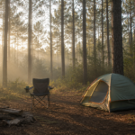
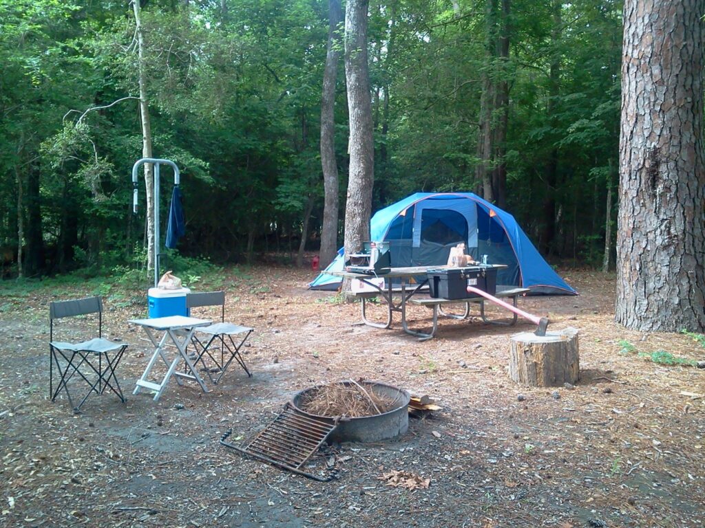
These sites are not campgrounds. There are no bathrooms, no water hookups, no electricity, no boat ramps right at your site. What you get is a cleared, designated spot on the river bank — some with a picnic table, fire ring, and lantern pole; some with just a table; one with nothing at all.
Here’s the full breakdown directly from the Corps:
Bluff 1 — Table, Fire Ring, Lantern Pole (2.0 miles below Bevilport, 3.8 miles above The Forks)
Bluff 2 — Table, Fire Ring, Lantern Pole (2.3 miles below Bevilport, 3.5 miles above The Forks)
Pickle’s Bluff — Table, Fire Ring
Hamilton Lake 1 — Table, Fire Ring, Lantern Pole (3.0 miles below Bevilport, 2.8 miles above The Forks)
Angelina 1 — Table, Fire Ring, Lantern Pole (4.6 miles below Bevilport, 1.2 miles above The Forks)
Angelina 2 — Table only
Angelina 3 — Table only
Angelina 4 — No amenities
Moon Lake 1 — Table, Fire Ring (5.3 miles below Bevilport, 0.5 miles above The Forks)
Moon Lake 2 — Table, Fire Ring (5.8 miles below Bevilport, right at The Forks)
Moon Lake 3 — Table only (5.8 miles below Bevilport, right at The Forks)
Warden 1 — Table, Fire Ring
Warden 2 — Table, Fire Ring
The furthest sites — the Moon Lake cluster near The Forks where the Neches and Angelina converge — are about 6 river miles from the Bevilport boat ramp. That’s a real paddle. Plan accordingly.
My recommendation for a first trip: Bluff 1 or Bluff 2. Close enough to Bevilport that you’re not exhausted when you arrive, and both have a fire ring and lantern pole. The bluff positioning also means you’re elevated above the river with a view that’s hard to beat at sunrise.
How to Get Your Permit (Don’t Skip This)
The sites are free, but a permit is required. Here’s exactly how it works:
Download the application at the official USACE Town Bluff page — look for the 2026 Primitive Application PDF link.
Fill out the top section completely. The Corps is clear about this: your application will not be processed if you skip the phone number, desired campsite, alternate campsite choice, boat and car numbers, or mailing address. Fill it all out.
Submit by email or fax:
- Email: TBPO@usace.army.mil
- Fax: 409-429-3188
Timing: Permits are available up to 6 weeks in advance and issued for up to 7 days at a time. Spring and fall weekends fill up — don’t wait until the week before.
One important note: only the official PDF application is processed. No photos, no Word documents, no screenshots. Download the actual form, fill it out, and send the PDF.
Getting There — The Bevilport Boat Ramp
The primary launch point for all 13 sites is the Bevilport boat ramp on the Angelina River. Get your vehicle and trailer situated here before you load out — this is the last paved reality you’ll see for a while.
From Jasper: Take US-190 west toward Woodville. The Bevilport access road is off US-190 — watch for Corps of Engineers signage for the Angelina-Neches/Dam B Wildlife Management Area.
A dependable motor or strong paddling setup matters here. Six river miles on a loaded camping rig is not a casual float — it’s a committed trip. Go with a motor if you have one. Paddlers, budget 2–3 hours each direction depending on current and how loaded your boat is.
Fishing the Neches and Angelina
This is one of the underrated fishing setups in SETX. B.A. Steinhagen holds largemouth bass, catfish, and crappie, and the river channels feeding the north end offer a completely different experience from open-water reservoir fishing. You’re working flooded timber, undercut banks, and the kind of structure that bass absolutely love.
Pack a rod even if fishing isn’t the main reason you’re going. When you’re camped on a river bank with a fire ring and nothing but bottomland hardwoods around you, not having a line in the water feels like a waste.
Wildlife — This Is the Real Deal
The Angelina-Neches/Dam B Wildlife Management Area is not a manicured park. This is East Texas bottomland in a mostly undisturbed state. What that means in practice:
Alligators are present throughout the river system. Keep gear out of the water’s edge, don’t leave food accessible from the river bank, and keep pets close. Standard SETX river rules — respect them and they’re not a problem.
Wood ducks, herons, egrets, and kingfishers work the river edges constantly. During spring and fall migration, the bottomland hardwoods along the Neches are exceptional birding territory.
White-tailed deer, feral hogs, and river otters are all documented in the WMA. Night sounds out here are genuinely wild — plan for it if you’re a light sleeper.
If you’re camping here with kids, the wildlife alone makes the trip. Several of the animals they’ll encounter — alligators, great blue herons, catfish, deer — are featured in our Wild Southeast Texas Wildlife Coloring Book. 35 real SETX species, great for the boat ride out and the downtime at camp.
What to Pack for a Boat-In Primitive Trip
Packing for boat-in camping is different from a drive-up site — everything you bring has to fit in the boat and be worth the weight.
Non-negotiables:
- Dry bags for anything electronic, sleeping gear, and food — one unexpected wave or a tippy launch and everything gets wet
- DEET-based insect repellent — mosquitoes along the Neches river corridor are relentless, especially at dawn and dusk
- Life jackets for everyone — the river moves, depths are unpredictable, and you’re in an actively managed waterway
- Headlamp with extra batteries — there are no lights out here
- Water filter or treatment tablets — no potable water at any of these sites
- A quality cooler that actually holds ice — you’re packing in everything you’ll eat and drink for your entire stay
If you’re still building out your camp kit and want to keep the cost down, our budget camping gear guide has solid options that hold up in SETX conditions.
Best Time to Go
October through November is the sweet spot. The humidity has broken, mosquitoes have thinned out significantly, temperatures are comfortable for sleeping, and the bottomland hardwoods along the river start showing fall color. Fall migration through SETX makes birding exceptional.
March through April is the other prime window — before the mosquitoes get bad and before the heat sets in.
Avoid midsummer unless you’re serious about the heat. A river bank campsite with no shade structure and 95% humidity is a different animal from a shaded state park site. It’s doable with the right gear, but bring extra water, a portable fan if your boat can handle it, and realistic expectations.
FAQ
Is camping at B.A. Steinhagen Lake really free? Yes — the primitive boat-in sites are free. You need a permit, which is also free, obtained by submitting the application to the USACE Town Bluff project office before your trip.
Do I need a boat to camp at these sites? Yes. All 13 primitive sites are accessible by boat only. The primary launch is the Bevilport boat ramp on the Angelina River.
How far is the paddle from Bevilport to the campsites? The closest sites (Bluff 1 and 2) are about 2 miles downriver. The furthest cluster (Moon Lake, near The Forks) is approximately 6 river miles. Most paddlers will want to target the Bluff or Hamilton Lake sites for their first trip.
Are there bathrooms at the primitive sites? No facilities at all. Pack a portable camp toilet or a trowel and follow Leave No Trace principles. Dig cat holes at least 200 feet from the river bank.
Can I have a campfire? Sites with fire rings are designated for fires. Always check for active burn bans in Jasper and Tyler Counties before your trip — check current status at the Texas A&M Forest Service burn ban map.
What fish can I catch at B.A. Steinhagen Lake? Largemouth bass, catfish, and crappie are the primary species. The river channels in the north end of the lake offer structure fishing in flooded timber — some of the better bass habitat in the SETX region.
For more free and low-cost camping across Southeast Texas, see our complete guide to the best campgrounds in Southeast Texas. And if you’re planning a trip on a tight budget, our budget camping gear guide covers the gear essentials without the high price tag.
Before you head out, grab the free Ultimate Family Camping Checklist — 82 items across 7 categories, built for camping in Southeast Texas. Free to download and worth reviewing before every trip.
This post contains affiliate links. If you purchase through these links, we may earn a small commission at no extra cost to you. Thank you for supporting SETX Camping!